 Resa Routes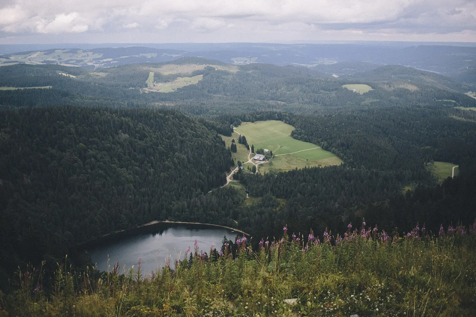
Hiking · Baden-Württemberg
Hiking trails around Feldberg & Titisee
251 waymarked hiking trails around Feldberg & Titisee (Baden-Württemberg), from OpenStreetMap. We calculated the length from the route’s course.
Photo: Tobias Nielsen · CC BY 2.0
.jpg)
At 1,493 m, the Feldberg is the highest mountain in the Black Forest and the highest in Germany outside the Alps. The area has been a nature reserve since 1937; at 42 km² it is the oldest and largest in Baden-Württemberg. Below the summit, the Feldsee lies in a steep-sided hollow, with the Titisee to the north-east. With nearly 300 routes, this is the densest region in our data: short connecting paths of the Black Forest Association, the Genießerpfade trails of the Hochschwarzwald and long-distance routes such as the Westweg and Mittelweg.
Good to know
- By public transport: from Freiburg Hbf take the Höllentalbahn to Titisee or Feldberg-Bärental, then bus 7300 to the Feldberg – about an hour in total, hourly. The KONUS guest card makes the trip free.
- The Feldbergbahn lift goes up to the Seebuck (1,448 m).
- The Haus der Natur at the Feldberg has an exhibition on the reserve; guided walks and the Feldbergsteig trail start there.
- Stay on the paths inside the reserve; the subalpine vegetation on the Feldberg is what it protects.
Our picks
- Genießerpfad - Feldbergsteig — A 12.3 km loop that starts and ends at the Haus der Natur.
- Titisee-Rundweg — The circuit around the Titisee, 7.8 km – flat and reachable by train.
- Feldberg - Schluchsee — A one-way Black Forest Association route from the Feldberg to the Schluchsee, 11.2 km.
- Genießerpfad - Menzenschwander Geißenpfad — A 9.8 km loop from Menzenschwand-Hinterdorf on the south side of the Feldberg.
E1European Long distance path E1 - part Germany, Baden-Wuerttemberg (alternative route Feldberg)
On OpenStreetMap ↗Kirchzarten - Feldberg
On OpenStreetMap ↗Todtnau - Feldbergpass
On OpenStreetMap ↗Genießerpfad - Feldbergsteig
On OpenStreetMap ↗Genießerpfad - Wasserfallsteig
On OpenStreetMap ↗Genießerpfad - Jägersteig
On OpenStreetMap ↗Große Seerunde
On OpenStreetMap ↗Feldberg - Schluchsee
On OpenStreetMap ↗Genießerpfad - Säbelthomaweg
On OpenStreetMap ↗Genießerpfad - Menzenschwander Geißenpfad
On OpenStreetMap ↗Genießerpfad - Hochschwarzwälder Hirtenpfad
On OpenStreetMap ↗Titisee-Rundweg
On OpenStreetMap ↗Walter-Wagner-Weg
On OpenStreetMap ↗2Holderreuthe
On OpenStreetMap ↗Naturlehrpfad Rinken
On OpenStreetMap ↗Lenzkirch - Windgfällweiher
On OpenStreetMap ↗Höllsteig
On OpenStreetMap ↗3Pfeifferhalde
On OpenStreetMap ↗Kesslerhöhenweg
On OpenStreetMap ↗Abzweig Hebelweg - Bernauer Kreuz Weg
On OpenStreetMap ↗Martin Heidegger Rundweg
On OpenStreetMap ↗Rotecksattel - Sommerhaldenweg
On OpenStreetMap ↗Stollenbach - Zastler Herderhäusle
On OpenStreetMap ↗Am Horneck - Zastler Eislöcher
On OpenStreetMap ↗Am Winterwald - Unterführung Wolfsgrund
On OpenStreetMap ↗Westweg (Variante Feldberger Hof)
On OpenStreetMap ↗Wildnis-Erlebnispfad
On OpenStreetMap ↗Am Horneck - Rinken
On OpenStreetMap ↗Lenzkirch - Saig
On OpenStreetMap ↗Emil-Thoma-Weg
On OpenStreetMap ↗Aha Auerhahn - Am Seeweg
On OpenStreetMap ↗Berger Höhe - Ob dem Rotenbach
On OpenStreetMap ↗Aha - Altglashütten
On OpenStreetMap ↗Dreiwege - Rufenholzplatz
On OpenStreetMap ↗Krunkelbachsattel - Menzenschwand Hinterdorf Kirche
On OpenStreetMap ↗Fürsatzhöhe - Spriegelsbach Neubierhäusle
On OpenStreetMap ↗Fischbach Kirche - Schluchsee Mattenweg
On OpenStreetMap ↗Bildsteinweg - Schluchsee Parkplatz Wolfsgrund
On OpenStreetMap ↗Äulemer Kreuz - Farnwitte
On OpenStreetMap ↗Burdharzwald - Stollenbach Kleiner Lift
On OpenStreetMap ↗Hugenbergrunde
On OpenStreetMap ↗Kammbühl - Spießhorn
On OpenStreetMap ↗Berger Höhe - Jacobuskreuz
On OpenStreetMap ↗Schluchsee Sonnhalde - Vogelhausweg
On OpenStreetMap ↗Bei der Radonquelle - Ruckenhütte
On OpenStreetMap ↗Bärental Bahnhof - Campingplatz Bankenhof
On OpenStreetMap ↗Kammendobel - Oberwittenbach
On OpenStreetMap ↗Brandenberg - Todtnauer Kriegerdenkmal
On OpenStreetMap ↗Bernauer Kreuz Weg - Mausboden
On OpenStreetMap ↗Hinterwaldkopfsattel - Spähnplatz
On OpenStreetMap ↗Am Milchberg - Scheibenfelsen
On OpenStreetMap ↗Rotkreuz - Saig Ochsen
On OpenStreetMap ↗Gfällmatte - Stollenbach Kleiner Lift
On OpenStreetMap ↗Ob der Hauseckhalde - Stollenbach
On OpenStreetMap ↗Bernauer Kreuz - Glockenführe
On OpenStreetMap ↗Im Hohspirn - Klausenhof
On OpenStreetMap ↗Pfeifferhalde - Prinz Max-Weg
On OpenStreetMap ↗Ob der Hauseckhalde - Stollenbacher Weide
On OpenStreetMap ↗Abzweig Fahl - Fahler Wasserfall Parkplatz
On OpenStreetMap ↗Rotkreuz - Vorderfalkau Lenzkircher Weg
On OpenStreetMap ↗